Imperial Circles around 1512

erstellt von Joachim Robert Moeschl last modified 2022-01-21T16:32:16+01:00
Contributors: Andreas Kunz

IEG-MAPS · Server für digitale historische Karten, CC BY-NC 4.0 International
Joachim Robert Moeschl, Imperial Circles ca. 1512, color graphic, 2008; source: IEG-MAPS, Institut für Europäische Geschichte, Mainz / © Andreas Kunz, 2008. URL: http://www.ieg-maps.uni-mainz.de/mapsp/mapp512RKreise.htm.

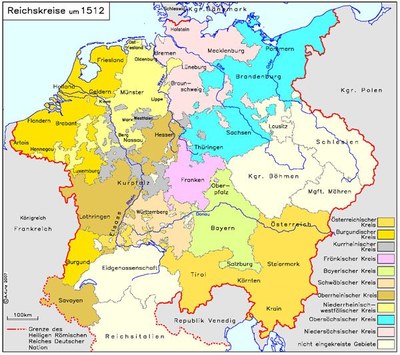
Reichskreise um 1512 IMG

The Holy Roman Empire of the German Nation was divided into six districts from 1500 and ten districts from 1512, which remained in effect until 1806. They performed various administrative tasks and sent delegates to the imperial government.


Joachim Robert Moeschl, Imperial Circles ca. 1512, color graphic, 2008; source: IEG-MAPS http://www.iegmaps.de/, Institut für Europäische Geschichte, Mainz / © Andreas Kunz, 2008. URL: http://www.ieg-maps.uni-mainz.de/mapsp/mapp512RKreise.htm.


Mitteleuropa
Politik
IEG(http://www.ieg-mainz.de)
yes
Medienbeschreibung
EGO(http://www.ieg-ego.eu)
Englisch
2008
2008
2000 - 2009

Bild
No image
Deutsch
Deutsch, Englisch
No file
No file


Region@Region@(BE)@freigabe


Reichskreise um 1512 IMG