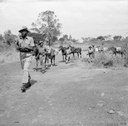
Ministry of Defence, Troops of the King's African Rifles carry supplies on horseback. They are escorted by armed soldiers on watch for Mau Mau terrorists, ca. 1952-1956. Source: Imperial War Museum, War Office Collection, Catalogue number MAU 345, http://www.iwm.org.uk/collections/item/object/205191303, IWM Non Commercial Licence © IWM (MAU 345).
William Shepherd: The Age of Discovery 1340-1600 (map), in: Shepherd, William. Historical Atlas. New York: Henry Holt and Company, 1911, pp. 108-110. Source: Perry-Castañeda Library Map Collection. Courtesy of the University of Texas Libraries, The University of Texas at Austin. http://www.lib.utexas.edu/maps/historical/shepherd_1911/shepherd-c-107-110.jpg, public domain.
John Pinkerton (1758–1826), Map of Cape Colony in Southern Africa, 1809; source: David Rumsey Map Collection, http://www.davidrumsey.com/maps4704.html, via Wikimedia Commons https://commons.wikimedia.org/wiki/File:Cape_Colony00.jpg. Creative Commons License BY-NC-SA 2.0.
William Shepherd: The Spread of Colonization, 1600-1700 (map), in: Shepherd, William. Historical Atlas. New York: Henry Holt and Company, 1911, p. 128. Source: Perry-Castañeda Library Map Collection. Courtesy of the University of Texas Libraries, The University of Texas at Austin. http://www.lib.utexas.edu/maps/historical/shepherd_1911/shepherd-c-128.jpg, public domain.
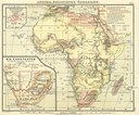
E. Debes (Hg.), Afrika, Politische Übersicht mit Nebenkarte der Kap-Staaten, Karte Nr. 24, in: E. Debes' Schul-Atlas für die Oberklassen höherer Lehranstalten, Sechste Auflage, Verlag von H. Wagner & E. Debes, Leipzig 1888. Quelle: Wikimedia Commons, http://commons.wikimedia.org/wiki/File:Debes_1888_Afrika.jpg, gemeinfrei.
"South America" from "Americanized Encyclopaedia Britannica", Vol. 1, Chicago 1892. Source: Perry-Castañeda Library Map Collection. Courtesy of the University of Texas Libraries, The University of Texas at Austin. http://www.lib.utexas.edu/maps/historical/south_america_1892.jpg, public domain.
Unbekannter Fotograf, Deutsche Siedlung im Iringahochland (Deutsch-Ostafrika, heute Tansania), ca. 1890-1914. Quelle: Koloniales Bildarchiv, Universitätsbibliothek Johann Christian Senckenberg Frankfurt/Main, https://ilissafrica.wordpress.com/2011/01/13/africa-in-historical-photographs/. Bildnummer 005-1118-18, http://www.ilissafrica.de/vk/?q=%22005-1118-18%22&c=dkg. Mit freundlicher Genehmigung.
User:Jengod, Das Gebiet der Red-River-Kolonie in der Ausdehnung, in der die Hudson's Bay Company sie 1812 Lord Selkirk überließ, mit der Grenzziehung zwischen USA und Kanada von 1818. Quelle: Wikimedia Commons, https://commons.wikimedia.org/wiki/File:Red-river-basin.png, Creative Commons Attribution-Share Alike 3.0 Unported.
European Settlement and Indian Tribes, 1750. (Karte der Besiedelung der nordamerikanischen Ostküste. Europäische Siedlungen getrennt von indigenen Gebieten, 1750.) Quelle: Maryland State Archives, http://msa.maryland.gov/ecp/10/214/images/00200001.gif, gemeinfrei.
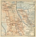
Wagner & Debes, Leipzig: Batavia (Jakarta), in: Indien: Handbuch Für Reisende, Verlag von Karl Baedeker in Leipzig, 1914. Source: Perry-Castañeda Library Map Collection. Courtesy of the University of Texas Libraries, The University of Texas at Austin. http://www.lib.utexas.edu/maps/historical/baedeker_indien_1914/txu-pclmaps-batavia_1914.jpg, public domain.
Unbekannter Fotograf, Der neuangekommene deutsche Siedler in Deutsch-Ost baut einen Brunnen (Deutsch-Ostafrika, heute Tansania), ca. 1890-1914. Quelle: Koloniales Bildarchiv, Universitätsbibliothek Johann Christian Senckenberg Frankfurt/Main, https://ilissafrica.wordpress.com/2011/01/13/africa-in-historical-photographs/. Bildnummer 005-1117-12, http://www.ilissafrica.de/vk/?q=%22005-1117-12%22&c=dkg. Mit freundlicher Genehmigung.
Atlas to Freeman's Historical Geography, Edited by J.B. Bury, Longmans Green and Co. Third Edition 1903. Source: Perry-Castañeda Library Map Collection. Courtesy of the University of Texas Libraries, The University of Texas at Austin. http://www.lib.utexas.edu/maps/historical/spanish_kingdoms.html, public domain.
U.S. Dept. of the Interior, Geological Survey, Exploration and Settlement 1850-1890, in: The National Atlas of the United States of America (Arch C. Gerlach, editor). Washington, D.C.: U.S. Dept. of the Interior, Geological Survey, 1970. Source: Perry-Castañeda Library Map Collection. Courtesy of the University of Texas Libraries, The University of Texas at Austin. http://www.lib.utexas.edu/maps/united_states/exploration_1850.jpg, public domain.
Stanford's Geographical Establishment, London: The World: Colonial Possessions and Commercial Highways, 1910, in: The Cambridge Modern History Atlas, edited by Sir Adolphus William Ward, G.W. Prothero, Sir Stanley Mordaunt Leathes, and E.A. Benians. Cambridge University Press; London 1912, map 140. Source: Perry-Castañeda Library Map Collection. Courtesy of the University of Texas Libraries, The University of Texas at Austin. http://www.lib.utexas.edu/maps/historical/ward_1912/world_1910.jpg, public domain.
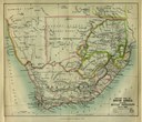
"Sketch Map of South Africa showing British Possessions July 1885" from the Scottish Geographical Magazine. Published by the Scottish Geographical Society and edited by Hugh A. Webster and Arthur Silva White. Volume I, 1885. Source: Perry-Castañeda Library Map Collection. Courtesy of the University of Texas Libraries, The University of Texas at Austin. http://www.lib.utexas.edu/maps/historical/south_africa_1885.jpg, public domain.


