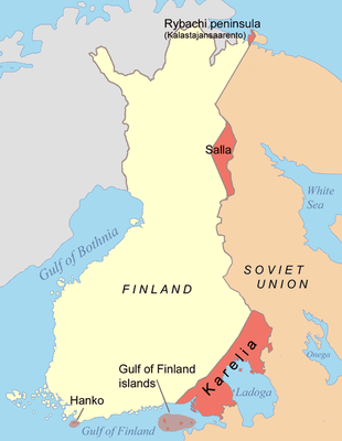
Winter War, 1940 - Map of the Territories Ceded by Finland

by map: Jniemenmaa last modified 2024-12-19T12:19:41+01:00
Wikimedia Commons, Creative Commons Attribution-Share Alike 3.0 Unported license
Finnish territories ceded in 1940, map, author: Jniemenmaa, 2005; image source: Wikimedia Commons, https://en.wikipedia.org/wiki/File:Finnish_areas_ceded_in_1940.png, Creative Commons Attribution-Share Alike 3.0 Unported license, https://creativecommons.org/licenses/by-sa/3.0/deed.en.

Karte Winterkrieg 1940

This map illustrates the areas (highlighted in orange) that Finland was compelled to cede to the Soviet Union following the Winter War of 1940, including substantial portions of Karelia and territories north of Lake Ladoga. The newly established southeastern border of Finland closely resembled the border outlined in the 1721 Treaty of Nystad. Finland was forced to relinquish several strategically significant islands in the Gulf of Finland and the fishing peninsula in the Norwegian Sea. Moreover, under the terms of the agreement, Hanko, situated in southwestern Finland, was to be leased to the Soviet Union for thirty years as a naval base.


Finnish territories ceded in 1940, map, author: Jniemenmaa, 2005; image source: Wikimedia Commons, Creative Commons Attribution-Share Alike 3.0 Unported license.


Northern Europe
Politics, Military
IEG(http://www.ieg-mainz.de)
yes
Media Description
HTML
EGO(http://www.ieg-ego.eu)
English
1940
1940
1940 - 1949

Finnish territories ceded in 1940
Winter War Map Finland
Image
No image
German
German, English
No file
CC by-nc-nd 3.0 Germany - Attribution, Noncommercial, No Derivative Works
No file


Karte Winterkrieg 1940