The World: Colonial Possessions and Commercial Highways, 1910

erstellt von Stanford's Geographical Establishment last modified 2020-05-25T10:39:38+01:00
Courtesy of the University of Texas Libraries, The University of Texas at Austin.
Stanford's Geographical Establishment, The World: Colonial Possessions and Commercial Highways, 1910, map, in: Adolphus William Ward et al. (ed.), The Cambridge Modern History Atlas, London 1912, map 140; source: Perry-Castañeda Library Map Collection. Courtesy of the University of Texas Libraries, The University of Texas at Austin, http://www.lib.utexas.edu/maps/historical/ward_1912/world_1910.jpg, public domain.

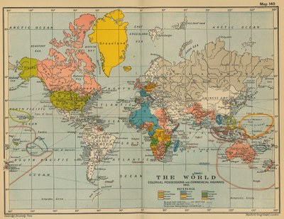
Stanford's Geographical Establishment, London: The World: Colonial Possessions and Commercial Highways, 1910, in: The Cambridge Modern History Atlas, edited by Sir Adolphus William Ward, G.W. Prothero, Sir Stanley Mordaunt Leathes, and E.A. Benians. Cambridge University Press; London 1912, map 140. Source: Perry-Castañeda Library Map Collection. Courtesy of the University of Texas Libraries, The University of Texas at Austin. http://www.lib.utexas.edu/maps/historical/ward_1912/world_1910.jpg, public domain.


Stanford's Geographical Establishment, The World: Colonial Possessions and Commercial Highways, 1910, map, in: Adolphus William Ward et al. (ed.), The Cambridge Modern History Atlas, London 1912, map 140; source: Perry-Castañeda Library Map Collection, courtesy of the University of Texas Libraries, The University of Texas at Austin, public domain.


Mitteleuropa, Osteuropa, Nordeuropa, Westeuropa, Südeuropa, Außereuropäische Welt
Politik, Migration, Reise
IEG(http://www.ieg-mainz.de)
no
Medienbeschreibung
HTML
EGO(http://www.ieg-ego.eu)
Englisch
1910
1910
1910 - 1919

World Colonial Possessions and Commercial
Bild
No image
Englisch
Deutsch, Englisch
No file
No file