The UN partition plan of 1947

by U.S. Central Intelligence Agency last modified 2020-05-25T10:25:24+01:00
Wikimedia Commons (public domain)
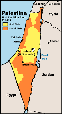
The UN partition plan of 1947, map, 1973; source: U.S. Central Intelligence Agency (ed.): Issues in the Middle East: Atlas, 1973; Wikimedia Commons http://commons.wikimedia.org/wiki/File:UN_Partition_Plan_For_Palestine_1947.png, public domain.

Der UN-Teilungsplan von 1947; Karte, 1973; Bildquelle: U.S. Central Intelligence Agency (Hg.): Issues in the Middle East: Atlas, 1973. http://commons.wikimedia.org/wiki/File:UN_Partition_Plan_For_Palestine_1947.png, gemeinfrei.

The UN partition plan of 1947 stipulated the division of Palestine into a Jewish and an Arab state while Greater Jerusalem was to be put under international control. As had happened with the Peel Commission's proposal in 1937, this plan was also accepted by the majority of the Yishuv and rejected by the Arab states, which led to its failure.


The UN partition plan of 1947, map, 1973; source: U.S. Central Intelligence Agency (ed.): Issues in the Middle East: Atlas, 1973; Wikimedia Commons http://commons.wikimedia.org/wiki/File:UN_Partition_Plan_For_Palestine_1947.png, public domain.


Non-European World
Politics, Religion, Migration, Travel
IEG(http://www.ieg-mainz.de)
yes
Media Description
HTML
EGO(http://www.ieg-ego.eu)
English
1947
1947
1940 - 1949

UN partition plan of 1947
Image
No image
German
German, English
No file
No file