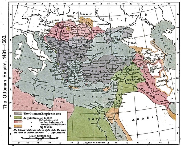
The Ottoman Empire Between 1481 and 1683

by unknown author last modified 2020-05-25T10:50:44+01:00
The University of Texas at Austin
The Ottoman Empire 1481–1683, map, 1923, unknown author; source: Shepherd, William R: The Historical Atlas, New York 1923. Digitalized version: The University of Texas at Austin, http://www.lib.utexas.edu/maps/historical/shepherd/ottoman_empire_1481-1683.jpg. Courtesy of the University of Texas Libraries, The University of Texas at Austin.

The Ottoman Empire, 1481–1683, Karte, 1923, unbekannter Ersteller; Bildquelle: Shepherd, William R.: The Historical Atlas, New York, 1923. Digitalisat: The University of Texas at Austin, http://www.lib.utexas.edu/maps/historical/shepherd/ottoman_empire_1481-1683.jpg.

The map shows how the Ottoman Empire expanded between 1481 and 1683. The blue area denotes its territory in 1481. Conquests up to 1520 are marked in green, up to 1566 in red, and up to 1683 in brown.


The Ottoman Empire 1481–1683, map, 1923, unknown author; source: Shepherd, William R: The Historical Atlas, New York 1923. Digitalized version: The University of Texas at Austin, http://www.lib.utexas.edu/maps/historical/shepherd/ottoman_empire_1481-1683.jpg. Courtesy of the University of Texas Libraries, The University of Texas at Austin.


Balkan Peninsula, Eastern Europe, Non-European World
Politics
IEG(http://www.ieg-mainz.de)
yes
Media Description
HTML
EGO(http://www.ieg-ego.eu)
English
1481
1683
1630 - 1639, 1550 - 1559, 1620 - 1629, 1540 - 1549, 1600 - 1609, 1580 - 1589, 1610 - 1619, 1490 - 1499, 1500 - 1509, 1480 - 1489, 1520 - 1529, 1590 - 1599, 1530 - 1539, 1560 - 1569, 1570 - 1579, 1510 - 1519

Ottoman Empire Between 1481 and
Image
No image
German
German, English
No file
No file