The Development of the Volcanic Island Krakatoa 1880–2005

erstellt von Sémhur last modified 2023-07-06T11:39:57+01:00
Wikimedia Commons, CC BY-SA 3.0.
Development of the Volcanic Island Krakatau, Indonesia between 1880 and 2005, animated map, creator: Sémhur; source: Wikimedia Commons, http://commons.wikimedia.org/wiki/File:Krakatoa_evolution_map-en.gif, Creative Commons Attribution-Share Alike 3.0 Unported, https://creativecommons.org/licenses/by-sa/3.0/deed.en.

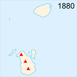
Die Entwicklung der Vulkaninsel Krakatau 1880–2005

This animated map (please click) shows the development of the volcanic island if Krakatoa between 1880 and 2005. The eruption of 1883 completely destroyed the island, but a new one hs been forming in its place since 1927 and continues to grow: "Anak Krakatoa", "the child of Krakatoa".


Development of the Volcanic Island Krakatau, Indonesia between 1880 and 2005, animated map, creator: Sémhur; source: Wikimedia Commons, http://commons.wikimedia.org/wiki/File:Krakatoa_evolution_map-en.gif, Creative Commons Some Rights Reserved Attribution-ShareAlike 3.0 Unported (CC BY-SA 3.0).


Außereuropäische Welt
Gesellschaft, Soziales, Bildung, Wissenschaft
IEG(http://www.ieg-mainz.de)
yes
Medienbeschreibung
HTML
EGO(http://www.ieg-ego.eu)
Deutsch
1880
2005
1880 - 1889, 1890 - 1899, 1900 - 1909, 1910 - 1919, 1920 - 1929, 1930 - 1939, 1940 - 1949, 1950 - 1959, 1960 - 1969, 1970 - 1979, 1980 - 1989, 1990 - 1999, 2000 - 2009

Bild
No image
Deutsch
Deutsch, Englisch
No file
No file