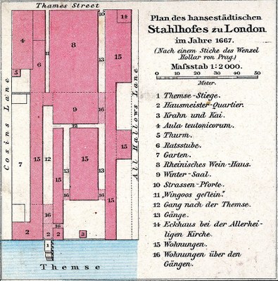
This drawing shows the so-called "Stahlhof," the Hanseatic League's branch office in London, as it was designed in 1667. The area was located on the north bank of the Thames and had been transferred to the Hanseatic merchants by the English King Edward IV (1442–1483) in 1475 (after the "Peace of Utrecht" in 1474). On the approximately 7000 m² property, which was bordered by a wall, there were commercial and residential buildings, a garden and a crane. The site was sold by the legal successors of the Hanseatic League, the Hanseatic cities of Lübeck, Bremen and Hamburg, in 1853. Since 1866, it has been the site of Cannon Street station.
Drawing of Hanseatic Steelyard in London in 1667, 1886; source: Richard Andree (ed.): G. Droysens Allgemeiner Historischer Handatlas (Plate 28), Bielefeld et al. 1886, Wikimedia Commons, https://commons.wikimedia.org/wiki/File:Droysens-28a.jpg,  Creative Commons Attribution-ShareAlike 3.0 Unported (CC BY-SA 3.0), https://creativecommons.org/licenses/by-sa/3.0/deed.en.


 Creative Commons Attribution-ShareAlike 3.0 Unported (CC BY-SA 3.0),