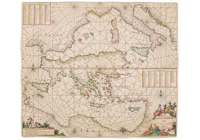
Sjökort över medelhavet, ca. 1681

by EGO-Redaktion last modified 2020-05-25T10:38:08+01:00
Sjöhistoriska museet, public domain
Johannes van Keulen (1654–1715), Sjökort över medelhavet, map, ca. 1681; image source: Sjöhistoriska museet, https://digitaltmuseum.se/021025734406, public domain.

Sjökort över medelhavet, ca. 1681

The sea atlas (Sjöatlas: De nieuwe groote lichtende Zee–Fakkel) by the Dutch cartographer Johannes van Keulen was first published in 1681. It was revised and republished a number of times between then and the 18th century. This map shows the Mediterranean in two parts. The upper half of the image depicts the region from Gibraltar to Italy. The lower one shows the region from Italy to Syria.


Johannes van Keulen (1654–1715), Sjökort över medelhavet, map, ca. 1681; image source: Sjöhistoriska museet, https://digitaltmuseum.se/021025734406, public domain.


Central Europe, Southern Europe, Non-European World
Social Matters, Society, Media, Communication
IEG(http://www.ieg-mainz.de)
yes
Media Description
HTML
EGO(http://www.ieg-ego.eu)
English
1681
1681
1680 - 1689

Image
No image
German
German, English
No file
No file