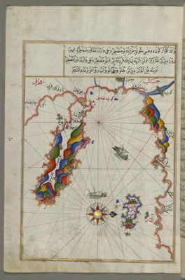
Piri Reis (ca. 1467–ca. 1554), Map of the Area West of the Island of Thasos and the Ayion Oros Peninsula, ca. 17th / 18th ct.

by map: Piri Reis (ca. 1467–ca. 1554) last modified 2024-08-26T09:42:22+01:00
Walters Art Museum, public domain
Piri Reis (ca. 1467–ca. 1554), Map of the Area West of the Island of Thasos and the Ayion Oros Peninsula, ink and pigments on laid European paper, 34 x 24 cm, Walters manuscript W.658, ca. 17th / 18th century; source: copy from Walters manuscript W.658 (unknown author), ca. 17th / 18th century (original from 1525); source: Walters Art Museum, art.thewalters.org/detail/79713, public domain.

Piri Reis (ca. 1467–ca.1554), Karte des Gebiets westlich der Insel Thasos und der Athos Halbinsel IMG

This Ottoman map from the 16th century shows Ayion Oros Peninsula with Mount Athos on the left and the Island of Thasos on the right (at the bottom). The peninsula including Mount Athos belongs to the larger peninsula Chalkidiki in the Aegean Sea. Mount Athos itself is more than 2,000 metres high and can only be reached by boat, despite its being connected with the main land. It is home to 20 Orthodox monasteries and enjoys a status of autonomy in today's Greece.


Piri Reis (ca. 1467–ca. 1554), Map of the Area West of the Island of Thasos and the Ayion Oros Peninsula, ink and pigments on laid European paper, 34 x 24 cm, Walters manuscript W.658, ca. 17th / 18th century; Copy from Walters manuscript W.658 (unknown author), ca. 17th / 18th century (original from 1525); source: Walters Art Museum, http://art.thewalters.org/detail/79713 public domain.


IEG(http://www.ieg-mainz.de)
no
Media Description
HTML
EGO(http://www.ieg-ego.eu)
English

Image
No image
German
German, English
No file
No file