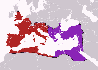
Map of the Western and Eastern Roman Empire in 395

by Geuiwogbil last modified 2024-02-29T15:54:52+01:00
Creative Commons Attribution ShareAlike 3.0 Germany
Map of the boundaries of the western and eastern Roman empires after the death of Theodosius I, in 395 AD, graphic, 2006: creator: Geuiwogbil; source: Wikimedia Commons, http://commons.wikimedia.org/wiki/File:Theodosius_I%27s_empire.png?uselang=de, Creative Commons Attribution ShareAlike 3.0 Germany

Karte des west- und oströmischen Reiches im Jahre 395 IMG

After the death of the Roman emperor Theodosius I (347–395), the Roman Empire was divided into a western and an eastern half, each of which was ruled by its own emperor. The eastern Roman emperor reigned in Constantinople (formerly Byzantium, currently Istanbul), while the western Roman emperor resided for a time in Milan, and at other times in Rome and Ravenna.


Map of the boundaries of the western and eastern Roman empires after the death of Theodosius I, in 395 AD, graphic, 2006: creator: Geuiwogbil; source: Wikimedia Commons, http://commons.wikimedia.org/wiki/File:Theodosius_I%27s_empire.png?uselang=de. Creative Commons Some Rights Reserved Creative Commons Attribution ShareAlike 3.0 Germany.


Southern Europe, Western Europe, Eastern Europe, Balkan Peninsula
Politics, Military
IEG(http://www.ieg-mainz.de)
yes
Media Description
HTML
EGO(http://www.ieg-ego.eu)
English
395
395
before 1450

Map of the boundaries of the western and eastern Roman empires after the death of Theodosius I, in 395 AD
Map of Western and Eastern
Image
No image
German
German, English
No file
No file