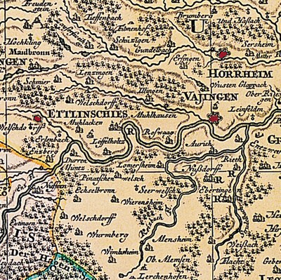
Map of the Foreign Villages (Waldenses Colonies) 1724

by Jacques Michal (ca. 1685–ca. 1750) last modified 2022-10-24T09:45:18+01:00
With the kind permission of Henri-Arnaud-Haus Ötisheim-Schönenberg
Jacques Michal (ca. 1685–ca. 1750), Foreign Villages (Waldenses Colonies), Map (Suevia Universa IX. Tabulus delineata) [excerpt], 1724; image source: with the kind permission of Henri-Arnaud-Haus Ötisheim-Schönenberg https://waldenser.org/ueber-uns/henri-arnaud-haus/.

Karte der Welschdörfer (Waldenserkolonien) 1724 IMG

This map, which was published in 1725 by Matthias Seutter (1678–1756), is the first to contain the Waldenses colonies that were built in Württemberg in 1699–1701. Notice how numerous Waldenses villages are labelled as "Welschdorf" (foreign village), and Pinache and Serres  are referred to as "Pinatschenwelsch" (foreign Pinache) and "Seerwelsch" (foreign Seer).


Jacques Michal (ca. 1685–ca. 1750), Foreign Villages (Waldenses Colonies), Map (Suevia Universa IX. Tabulus delineata) [excerpt], 1724; image source: with the kind permission of Henri-Arnaud-Haus Ötisheim-Schönenberg.


Central Europe
Social Matters, Society, Religion, Migration, Travel
IEG(http://www.ieg-mainz.de)
no
Media Description
HTML
EGO(http://www.ieg-ego.eu)
1720 - 1729

Image
No image
German
German, English
No file
No file