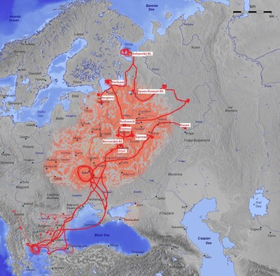
Map of the Kievan Rus', 14th–16th century

erstellt von Captain Blood, Britta Müller-Schauenburg last modified 2023-10-05T13:48:05+01:00
Contributors: Captain Blood, Britta Müller-Schauenburg

CC BY-SA 3.0 DE
Kievan Rus', 14th–16th century, map, 2006, author: Captain Blood, Britta Müller-Schauenburg, source: Wikimedia Commons, online: http://commons.wikimedia.org/wiki/File:Kievan_Rus_en.jpg?uselang=de, Creative Commons Attribution-ShareAlike 3.0 Germany (CC BY-SA 3.0 DE).

Kiewer Rus Karte 2 IMG

When the monastic culture spread under the influence of Sergei Radonezsky and his disciples, it resulted in a spiritual settlement of the north. This map of Kievan Rus' shows the regions to which this "monastic colonization" of the 14th–16th century extended.


Kievan Rus', 14th–16th century, map, 2006, author: Captain Blood, Britta Müller-Schauenburg, source: Wikimedia Commons, http://commons.wikimedia.org/wiki/File:Kievan_Rus_en.jpg?Creative Commons Some Rights Reserved Creative Commons License Attribution-ShareAlike 3.0 Unported (CC BY-SA 3.0 DEED), https://creativecommons.org/licenses/by-sa/3.0/deed.


Balkanhalbinsel, Osteuropa
Politik
IEG(http://www.ieg-mainz.de)
yes
Medienbeschreibung
HTML
EGO(http://www.ieg-ego.eu)
Englisch
1300
1600
before 1450, 1450 - 1459, 1460 - 1469, 1470 - 1479, 1480 - 1489, 1490 - 1499, 1500 - 1509, 1510 - 1519, 1520 - 1529, 1530 - 1539, 1540 - 1549, 1550 - 1559, 1560 - 1569, 1570 - 1579, 1580 - 1589, 1590 - 1599

Bild
No image
Deutsch
Deutsch, Englisch
No file
No file


Religion@Religion@(ÜB)@freigabe