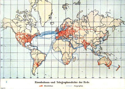
Global railway and telegraph concentration 1901
erstellt von
—
last modified
2021-05-31T17:25:07+01:00
Wikimedia Commons
Wikimedia Commons
Cartographic representation of the railway and telegraph density of the earth; source: Andree, Richard / Scobel, Albert (eds.): Allgemeiner Handatlas in 126 Haupt- und 139 Nebenkarten nebst vollständigem alphabetischem Namensverzeichnis, 4. ed., Bielefeld 1901, p. 17 (Kolonial- und Weltverkehrskarte), Wikimedia commons, http://commons.wikimedia.org/wiki/File:Eisenbahnen-_und_Telegraphendichte_der_Erde_um_1900.jpg?uselang=de, public domain.
European Overseas Rule@European Overseas Rule@(ÜB)@freigabe
Europeans Encounter the World in Travelogues, 1450–1900@Travelogues@(BE)@freigabe
Internationalism@Internationalism@(ÜB)@freigabe
Pilgrimage@Pilgrimage@(ÜB)@vorankündigung
Religion@Religion@(ÜB)@freigabe
Technology@Technology@(ÜB)@freigabe
The "Yellow Peril"@Yellow Peril@(BE)@freigabe
Transport and Travel@Transport and Travel@(ÜB)@vorankündigung

