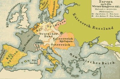
Europe after the Congress of Vienna of 1815
erstellt von
—
last modified
2023-11-23T13:53:44+02:00
Creative Commons Attribution ShareAlike 3.0 Germany
Creative Commons Attribution ShareAlike 3.0 Germany
Alfred Baldamus (1856–1908), Europe after the Congress of Vienna 1815, coloured drawing, scan: Massimo Macconi, in: F. W. Putzgers historischer Schul-Atlas zur alten, mittleren und neuen Geschichte, Bielefeld et al. 1918, p. 104; source: Wikimedia Commons, http://commons.wikimedia.org/wiki/File:Europa1814.jpg?uselang=de. Creative Commons Attribution ShareAlike 3.0 Germany.
Censorship and Freedom of the Press@Censorship and Freedom of the Press@(ÜB)@freigabe
Codification Movements@Codification Movements@(BE)@freigabe
Greek War of Independence (1821–1832)@Greek War of Independence@(BE)@freigabe
Lingua Franca@Lingua Franca@(BE)@freigabe
Pan-Slavism@Pan-Slavism@(BE)@freigabe
Pan-Turkism@Pan-Turkism@(BE)@freigabe
Political Migration (Exile)@Political Migration (Exile)@(ÜB)@freigabe
Royal and imperial courts and dynasties@Royal and imperial courts and dynasties@(ÜB)@freigabe


 Creative Commons Attribution ShareAlike 3.0 Germany