Epicentre of the Earthquake and the Spread of the Tsunami 2004

by Vasily V. Titov last modified 2023-07-06T11:47:28+01:00
National Oceanic and Atmospheric Administration via Wikimedia Commons, public domain.
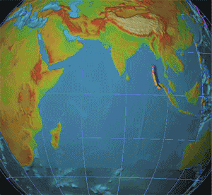
Vasily V. Titov: Epicentre of the Earthquake and the Spread of the Tsunami 2004, animated map; source: National Oceanic and Atmospheric Administration via Wikimedia Commons, http://commons.wikimedia.org/wiki/File:2004_Indonesia_Tsunami_Complete.gif, public domain.

Tsunami 2004

This animated map (please click) shows the epicentre of the earthquake near Sumatra in the Indian Ocean and the subsequent tsunami, which hit the coastlines of nearby states on 26 December 2004. At 9.1 on the Richter scale, it was the third-strongest earthquake ever recorded. The tsunami claimed over 100,000 victims and destroyed large coastal areas in the eastern Indian Ocean.


Vasily V. Titov: Epicentre of the Earthquake and the Spread of the Tsunami 2004, animated map; source: National Oceanic and Atmospheric Administration via Wikimedia Commons, http://commons.wikimedia.org/wiki/File:2004_Indonesia_Tsunami_Complete.gif, public domain.


Non-European World
Education, Sciences, Social Matters, Society
IEG(http://www.ieg-mainz.de)
yes
Media Description
HTML
EGO(http://www.ieg-ego.eu)
German
2004
2004
2000 - 2009

Image
No image
German
German, English
No file
No file


Tsunami 2004