Map of the Swiss Confederation at the Time of the Second War of Kappel in 1531

Map of the Swiss Confederation at the Time of the Second War of Kappel, towns drawn in green were the neutral, mediating side, orange represents the Catholic side, and those in brown were the Reformed side, map, 2018, Author: Marco Zanoli; source: Wikimedia Commons https://commons.wikimedia.org/wiki/File:Karte-Zweiter-Kappelerkrieg.png, Creative Commons Attribution-Share Alike 4.0 International license https://creativecommons.org/licenses/by-sa/4.0/deed.en.
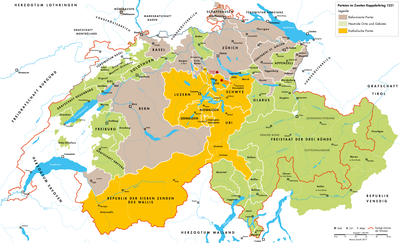
Karte der Eidgenossenschaft zur Zeit des Zweiten Kappelerkrieges 1531

This map shows the situation in the Old Swiss Confederation at the time of the Second War of Kappel (1531). The First War of Kappel, a conflict between Reformed and Catholic towns in Switzerland, was ended in 1529 without combat by a reconciliatory meal near Kappel. In the Second War of Kappel in 1531, the confrontation resumed. The starting point of these first European religious wars was the differences between the orthodox towns and towns that had adopted the new beliefs in the Swiss Confederation.


Map of the Swiss Confederation at the Time of the Second War of Kappel, towns drawn in green were the neutral, mediating side, orange represents the Catholic side, and those in brown were the Reformed side, map, 2018, Author: Marco Zanoli; source: Wikimedia Commons, Creative Commons Attribution-Share Alike 4.0 International license.


Central Europe
Military
IEG(http://www.ieg-mainz.de)
yes
Media Description
English
1529
1531

Map Swiss Confederation Time Second
Image
No image
German, English
No file
No file