Dufour Peak

erstellt von Photography: Jackph last modified 2024-05-06T11:31:15+01:00
Wikimedia Commons, public domain
Le Nordend (à gauche) et la pointe Dufour (à droite), colour photograph, 2007, photographer: Jackph; image source: Wikimedia Commons, http://commons.wikimedia.org/wiki/File:MonteRosa004.jpg?uselang=de, public domain.

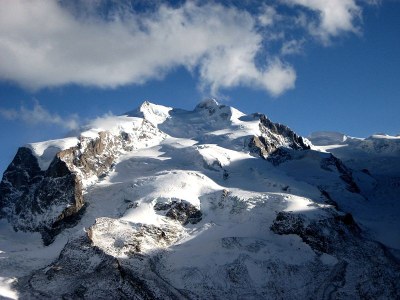
 

Le Nordend (à gauche) et la pointe Dufour (à droite), Farbphotographie, 2007, Photograph: Jackph; Bildquelle: Wikimedia Commons, http://commons.wikimedia.org/wiki/File:MonteRosa004.jpg?uselang=fr.

Dufour Peak (on the right in the photograph) is the highest peak in Switzerland at 4,634 m. It was named after General Guillaume-Henri Dufour (1787–1875), who oversaw the compilation of the first topographical map of Switzerland between 1833 and 1865.


Le Nordend (à gauche) et la pointe Dufour (à droite), colour photograph, 2007, photographer: Jackph; source: Wikimedia Commons, http://commons.wikimedia.org/wiki/File:MonteRosa004.jpg?uselang=de, public domain.


Mitteleuropa
Militär, Bildung, Wissenschaft
IEG(http://www.ieg-mainz.de)
yes
Medienbeschreibung
HTML
EGO(http://www.ieg-ego.eu)
Englisch
1787
1875
1830 - 1839, 1840 - 1849, 1810 - 1819, 1800 - 1809, 1780 - 1789, 1790 - 1799, 1820 - 1829, 1850 - 1859, 1860 - 1869, 1870 - 1879

Le Nordend (à gauche) et la pointe Dufour (à droite)
Bild
No image
Deutsch
Deutsch, Englisch
No file
No file


Land@Land@(BE)@freigabe


Dufourspitze IMG