Canal du Midi

erstellt von unknown creator last modified 2024-06-27T11:08:42+01:00
Contributors: unknown creator

Gallica, Bibliothèque nationale de France, département Cartes et plans, public domain
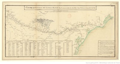
Carte générale du canal royal pour la communication des deux mers depuis Toulouse jusqu'au port de Cette, map, 40 x 80 cm, 18th century, unknown creator; source: Gallica, Bibliothèque nationale de France, département Cartes et plans, GE C-2626 http://gallica.bnf.fr/ark:/12148/btv1b53029748t, public domain.

Karte des Canal du Midi

This historical map of the Canal du Midi ("canal of the south") shows the course of the canal formerly known as the Canal royal en Languedoc ("royal canal in Languedoc") between Toulouse and the Mediterranean at Sète. The 240-km-long canal was completed in 1681 and reconfigured a number of times thereafter. Today, this waterway, which was declared a UNESCO World Cultural Heritage Site in 1996, is no longer used for transporting goods and passengers and instead plays a large role in the tourism of the region.


Carte générale du canal royal pour la communication des deux mers depuis Toulouse jusqu'au port de Cette, map, 40 x 80 cm, 18th century, unknown creator; source: Gallica, Bibliothèque nationale de France, département Cartes et plans, GE C-2626 http://gallica.bnf.fr/ark:/12148/btv1b53029748t, public domain.

Westeuropa, Südeuropa
Wirtschaft, Technologie, Gesellschaft, Soziales
IEG(http://www.ieg-mainz.de)
yes
Medienbeschreibung
HTML
EGO(http://www.ieg-ego.eu)
Englisch
1700
1800
1700 - 1709, 1710 - 1719, 1720 - 1729, 1730 - 1739, 1740 - 1749, 1750 - 1759, 1760 - 1769, 1770 - 1779, 1780 - 1789, 1790 - 1799

Bild
No image
Deutsch
Deutsch, Englisch
No file
No file


Karte des Canal du Midi