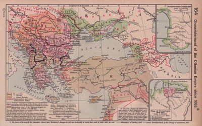
Zerteilung des Osmanischen Reiches seit 1683

erstellt von William R. Shepherd zuletzt geändert 2020-05-25T10:29:23+01:00
Courtesy of the University of Texas Libraries, The University of Texas at Austin.
William R. Shepherd: Dismemberment of the Ottoman Empire since 1683; Detailkarten: Southwestern Crimea, 1854. Plan of Sevastopol, 1854-1855. Karte aus dem Historical Atlas von William R. Shepherd, 1923. Bildquelle: Perry-Castañeda Library Map Collection. Courtesy of the University of Texas Libraries, The University of Texas at Austin. http://www.lib.utexas.edu/maps/historical/shepherd/ottoman_dismemberment.jpg, gemeinfrei.

William R. Shepherd: Dismemberment of the Ottoman Empire since 1683; insets: Southwestern Crimea, 1854. Plan of Sevastopol, 1854-1855. Map from the Historical Atlas by William R. Shepherd, 1923. Source: Perry-Castañeda Library Map Collection. Courtesy of the University of Texas Libraries, The University of Texas at Austin. http://www.lib.utexas.edu/maps/historical/shepherd/ottoman_dismemberment.jpg, public domain.


William R. Shepherd: Dismemberment of the Ottoman Empire since 1683; Detailkarten: Southwestern Crimea, 1854. Plan of Sevastopol, 1854-1855. Karte aus dem Historical Atlas von William R. Shepherd, 1923. Bildquelle: Perry-Castañeda Library Map Collection. Courtesy of the University of Texas Libraries, The University of Texas at Austin, gemeinfrei.


Außereuropäische Welt, Balkanhalbinsel
Politik, Religion, Militär, Migration, Reise
IEG(http://www.ieg-mainz.de)
ja
Medienbeschreibung
HTML
EGO(http://www.ieg-ego.eu)
Deutsch
1863
1923
1680 - 1689, 1690 - 1699, 1700 - 1709, 1710 - 1719, 1720 - 1729, 1730 - 1739, 1740 - 1749, 1750 - 1759, 1760 - 1769, 1770 - 1779, 1780 - 1789, 1790 - 1799, 1800 - 1809, 1810 - 1819, 1820 - 1829, 1830 - 1839, 1840 - 1849, 1850 - 1859, 1860 - 1869, 1870 - 1879, 1880 - 1889, 1890 - 1899, 1900 - 1909, 1910 - 1919, 1920 - 1929

Zerteilung Osmanischen Reiches seit 1683
Bild
Kein Bild
Englisch
Deutsch, Englisch
Keine Datei
Keine Datei