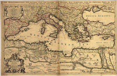
Mediterranean Sea divided into its Principall parts or seas

erstellt von Nicolas Sanson (1600–1667) zuletzt geändert 2020-05-25T10:24:46+01:00
Library of Congress, Geography and Map Division, gemeinfrei
Nicolas Sanson (1600–1667): Mediterranean Sea divided into its Principall parts or seas, Karte, 17. Jahrhundert; Bildquelle: Library of Congress, Geography and Map Division https://www.loc.gov/item/99466740/, gemeinfrei.

Mediterranean Sea divided into its Principall parts or seas IMG

Diese Karte aus dem 17. Jahrhundert zeigt die gesamte Mittelmeerregion, u.a. unterteilt in einen westlichen und einen östlichen Meeresteil.


Nicolas Sanson (1600–1667): Mediterranean Sea divided into its Principall parts or seas, Karte, 17. Jahrhundert; Bildquelle: Library of Congress, Geography and Map Division, gemeinfrei.

Südeuropa
IEG(http://www.ieg-mainz.de)
nein
Medienbeschreibung
HTML
EGO(http://www.ieg-ego.eu)
Deutsch
1620 - 1629, 1610 - 1619, 1600 - 1609, 1630 - 1639, 1640 - 1649, 1650 - 1659, 1660 - 1669, 1670 - 1679, 1680 - 1689, 1690 - 1699

Bild
Kein Bild
Deutsch
Keine Datei
Keine Datei