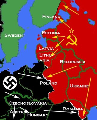
Karte Ost-/Mitteleuropa 1938–1940
erstellt von
—
zuletzt geändert
2022-03-18T19:55:20+02:00
Wikimedia Commons, Creative Commons Attribution-Share Alike 3.0 Unported
Wikimedia Commons, Creative Commons Attribution-Share Alike 3.0 Unported
Karte deutscher und sowjetischer Eingliederungen und Annexionen, sowie Besetzungen in Mittel- und Osteuropa (1938–1941), Ersteller: Mosedschurte; Bildquelle: Wikimedia Commons, https://commons.wikimedia.org/wiki/File:Nazi-Soviet_1941.png, Creative Commons Attribution-Share Alike 3.0 Unported.

