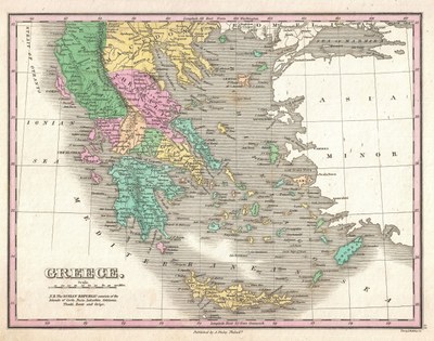
Griechenland und seine Regionen 1827

erstellt von Anthony Finley zuletzt geändert 2020-05-25T10:34:30+01:00
Geographicus Rare Antique Maps / Wikimedia Commons, gemeinfrei
Anthony Finley (1790–1840), Griechenland, Karte, undatiert, in: Finley, Anthony: A New General Altas, Comprising a Complete Set of Maps, representing the Grand Divisions of the Globe, Together with the several Empires, Kingdoms and States in the World; Compiled from the Best Authorities, and corrected by the Most Recent Discoveries, Philadelphia, 1827; Bildquelle: Geographicus Rare Antique Maps / Wikimedia Commons, http://commons.wikimedia.org/wiki/File:1827_Finely_Map_of_Greece_-_Geographicus_-_Greece-finley-1827.jpg, gemeinfrei.

Griechenland und seine Regionen 1827 IMG

Bitte klicken Sie auf das Bild, um zu einer größeren Ansicht zu gelangen.


Anthony Finley (1790–1840), Griechenland, Karte, undatiert, in: Finley, Anthony: A New General Altas, Comprising a Complete Set of Maps, representing the Grand Divisions of the Globe, Together with the several Empires, Kingdoms and States in the World; Compiled from the Best Authorities, and corrected by the Most Recent Discoveries, Philadelphia, 1827; Bildquelle: Geographicus Rare Antique Maps / Wikimedia Commons, http://commons.wikimedia.org/wiki/File:1827_Finely_Map_of_Greece_-_Geographicus_-_Greece-finley-1827.jpg, gemeinfrei.


Balkanhalbinsel
Recht, Verfassung, Politik
IEG(http://www.ieg-mainz.de)
nein
Medienbeschreibung
HTML
EGO(http://www.ieg-ego.eu)
Deutsch
1827
1827
1820 - 1829

Griechenland und Regionen 1827
Bild
Kein Bild
Deutsch
Deutsch
Keine Datei
Keine Datei