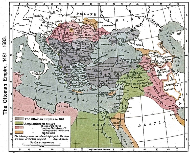
Das Osmanische Reich zwischen 1481 und 1683

erstellt von unbekannter Ersteller zuletzt geändert 2020-05-25T10:25:10+01:00
The University of Texas at Austin
The Ottoman Empire, 1481–1683, Karte, 1923, unbekannter Ersteller; Bildquelle: Shepherd, William R.: The Historical Atlas, New York, 1923. Digitalisat: The University of Texas at Austin The University of Texas at Austin, http://www.lib.utexas.edu/maps/historical/shepherd/ottoman_empire_1481-1683.jpg. Courtesy of the University of Texas Libraries, The University of Texas at Austin.

Quelle der Karte: The Historical Atlas by William R. Shepherd, 1923. Digitalisat: The University of Texas at Austin, http://www.lib.utexas.edu/maps/historical/shepherd/ottoman_empire_1481-1683.jpg.

Die Karte zeigt, wie sich das Osmanische Reich zwischen 1481 und 1683 ausdehnte. Der blaue Bereich kennzeichnet das Herrschaftsgebiet im Jahr 1481. Grün markiert sind die Eroberungen bis 1520, rot die Eroberungen bis 1566 und braun schließlich die Eroberungen bis 1683.


The Ottoman Empire, 1481–1683, Karte, 1923, unbekannter Ersteller; Bildquelle: Shepherd, William R.: The Historical Atlas, New York, 1923. Digitalisat: The University of Texas at Austin The University of Texas at Austin, http://www.lib.utexas.edu/maps/historical/shepherd/ottoman_empire_1481-1683.jpg. Courtesy of the University of Texas Libraries, The University of Texas at Austin.


Balkanhalbinsel, Osteuropa, Außereuropäische Welt
Politik
IEG(http://www.ieg-mainz.de)
nein
Medienbeschreibung
HTML
EGO(http://www.ieg-ego.eu)
Deutsch
1481
1683
1630 - 1639, 1550 - 1559, 1620 - 1629, 1640 - 1649, 1540 - 1549, 1600 - 1609, 1580 - 1589, 1610 - 1619, 1490 - 1499, 1680 - 1689, 1500 - 1509, 1480 - 1489, 1520 - 1529, 1590 - 1599, 1530 - 1539, 1560 - 1569, 1650 - 1659, 1570 - 1579, 1670 - 1679, 1510 - 1519, 1660 - 1669

Osmanische Reich zwischen 1481 und
Bild
Kein Bild
Deutsch
Deutsch, Englisch
Keine Datei
Keine Datei