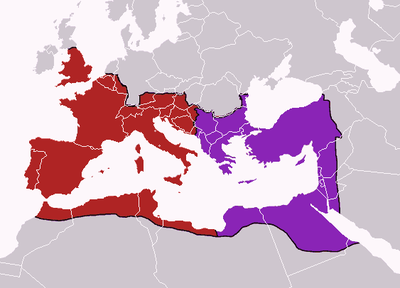
Karte des west- und oströmischen Reichs im Jahre 395
erstellt von
—
zuletzt geändert
2022-06-13T11:30:59+02:00
Creative Commons Attribution ShareAlike 3.0 Germany.
Creative Commons Attribution ShareAlike 3.0 Germany.
Map of the boundaries of the Western and Eastern Roman Empires after the death of Theodosius I, in 395 AD, Grafik, 2006: Ersteller: Geuiwogbil; Bildquelle: Wikimedia Commons, http://commons.wikimedia.org/wiki/File:Theodosius_I%27s_empire.png?uselang=de. Creative Commons Attribution ShareAlike 3.0 Germany.
Der Balkan@Balkan@(BE)@freigabe
Lingua Franca und Verkehrssprachen@Lingua Franca und Verkehrssprachen@(BE)@freigabe


