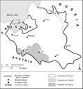
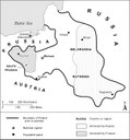
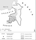
Maps of the three partitions of Poland in the 18th century
by
—
last modified
2022-07-29T16:44:42+02:00
Library of congress, public domain
Library of congress, public domain
The three partitions of Poland, maps, 1992, Federal Research Division of the Library of Congress; source: Glenn E. Curtis and Library Of Congress, Federal Research Division: Poland: A Country Study, Washington, D.C. 1994, digital copy: https://www.loc.gov/item/93046235/, public domain.
Ashkenazi Jews in Early Modern Europe@Ashkenazi Jews@(BE)@freigabe
Border Regions@Border Regions@(ÜB)@freigabe
Cultural Transfer@Cultural Transfer@(ÜB)@freigabe
East Central Europe@East Central Europe@(BE)@freigabe
East and South-East European Jews in the 19th and 20th Centuries@East and South-East European Jews@(BE)@freigabe
Enlightenment Jewish Style: The Haskalah Movement in Europe@Haskalah Movement@(BE)@freigabe
Europe's Mosaic of Languages@Mosaic of Languages@(ÜB)@freigabe
Hasidism: A Mystical Movement Within Eastern European Judaism@Hasidism@(BE)@freigabe
Jewish Migration@Jewish Migration@(ÜB)@freigabe
Mental Maps: The Cognitive Mapping of the Continent as an Object of Research of European History@Mental Maps@(ÜB)@freigabe
Pan-Slavism@Pan-Slavism@(BE)@freigabe
Salon@Salon@(BE)@freigabe
State Forms and State Systems in Modern Europe@State Forms and State Systems@(BE)@freigabe
The French Revolutionary and Napoleonic Wars@Revolutionary and Napoleonic Wars@(BE)@freigabe
Translation@Translation@(ÜB)@freigabe


