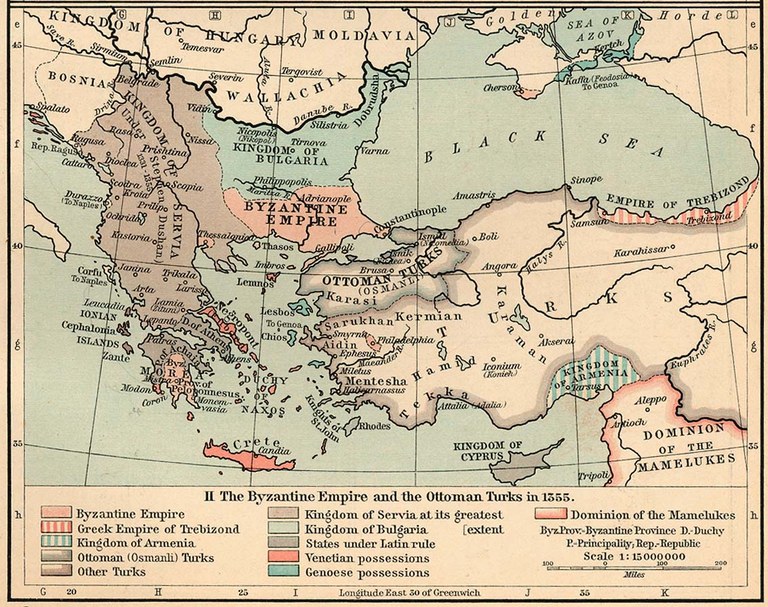
Das Osmanische Reich im Jahr 1355

erstellt von unbekannter Ersteller zuletzt geändert 2020-05-25T10:17:14+01:00
The University of Texas
The Byzantine Empire and the Ottoman Turks in 1355, Karte, 1911, unbekannter Ersteller; Bildquelle: Shepherd, William R.: The Historical Atlas, New York, 1911. Digitalisat: The University of Texas at Austin, http://www.lib.utexas.edu/maps/historical/shepherd/byzantine_empire_1355.jpg. Courtesy of the University of Texas Libraries, The University of Texas at Austin.

Quelle der Karte: The Historical Atlas by William R. Shepherd, 1911.  Digitalisat: The University of Texas at Austin, http://www.lib.utexas.edu/maps/historical/shepherd/byzantine_empire_1355.jpg

Die Karte zeigt die Ausdehnung des Osmanischen Reiches im Jahr 1355.


The Byzantine Empire and the Ottoman Turks in 1355, Karte, 1911, unbekannter Ersteller; Bildquelle: Shepherd, William R.: The Historical Atlas, New York, 1911. Digitalisat: The University of Texas at Austin, http://www.lib.utexas.edu/maps/historical/shepherd/byzantine_empire_1355.jpg. Courtesy of the University of Texas Libraries, The University of Texas at Austin.


Balkanhalbinsel, Außereuropäische Welt
Politik
IEG(http://www.ieg-mainz.de)
nein
Medienbeschreibung
HTML
EGO(http://www.ieg-ego.eu)
Deutsch
1355
1355
before 1450

The Byzantine Empire and the Ottoman Turks in 1355
Osmanische Reich im Jahr 1355
Bild
Kein Bild
Deutsch
Deutsch, Englisch
Keine Datei
Keine Datei