Nova Palmae Civitatis – trace italienne

by unknown artist last modified 2020-05-25T10:02:55+01:00

Nova Palmae Civitatis, map, ca. 16th century, unknown artist; source: Georg Braun et al. (ed.): Civitates orbis terrarvm (5): Vrbivm Praecipvarvm Mundi Theatrvm Qvintvm: [Coloni[a]e Agrippin[a]e. 20. die Septemb. Anno M.DC.XVII.] — [Coloniae Agrippinae], [1599?] [VD16 B 7183] [VD17 12:656254M], digital copy: Universitätsbibliothek Heidelberg, Heidelberger historische Bestände – digital, https://digi.ub.uni-heidelberg.de/diglit/braun1599bd5/0228, CC BY-SA 3.0 DE https://creativecommons.org/licenses/by-sa/3.0/de/

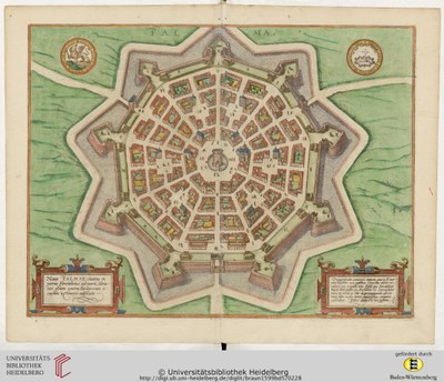
Nova Palmae Civitatis – trace italienne

A trace italienne or bastion fort denotes a style of fortification that evolved during the early modern period of gunpowder. The design of bastion forts as a pentagon or hexagon and with bastions at the corners of the wall eliminated so-called blind spots or dead zones (as were common to ring-shaped fortifications) and allowed fire on attackers from protected positions. The trace italienne was a response to the increasing threat of cannons dominating the battlefield in the mid-15th century.


Nova Palmae Civitatis, map, ca. 16th century, unknown artist; source: Georg Braun et al. (ed.): Civitates orbis terrarvm (5): Vrbivm Praecipvarvm Mundi Theatrvm Qvintvm: [Coloni[a]e Agrippin[a]e. 20. die Septemb. Anno M.DC.XVII.] — [Coloniae Agrippinae], [1599?] [VD16 B 7183] [VD17 12:656254M], digital copy: Universitätsbibliothek Heidelberg, Heidelberger historische Bestände – digital, CC BY-SA 3.0 DE.

Central Europe
Military
IEG(http://www.ieg-mainz.de)
no
HTML
EGO(http://www.ieg-ego.eu)
English

Image
No image
English
English
No file
No file